The Obligatory
"Play safe. Ski only in clockwise direction. Let's all have fun together."
Tuesday, September 05, 2006
Mount San Antonio
After two days of equal parts extreme nerdiness and traditional Labor Day lounging, the third day of this Three Day Weekend needed some outdoorsmanship to round out the combo. And thus, I woke up extra early to head out east to the Angeles National Forest. I'd heard the Crystal Lake campground area was open, and it had a bunch of peaks I wanted to tackle.
Unfortunately, it was still closed. Fire damage. For some reason that day - maybe due to an extra influx of vacationing tourists on their day off - the rangers were uncharacteristically unhelpful. I was far east in the forest, surrounded by short trails. I didn't drive all the way out there to do something easy. What was left? Mount Baldy?
The tallest mountain in Los Angeles County, 'Old Baldy' - or more accurately Mount San Antonio - is clearly visible from the city of Los Angeles. You know, when there's no smog around. It's also the birthplace of Southern California's ski resort industry. Oh, and it's over 10,000 feet high.
I wasn't planning on doing Mt. Baldy yet, but hell - my CamelBak was full, and I wasn't about to drive back home to do laundry. So off to Mount Baldy I went.
After driving through the picturesque Alpine ski village, the Accord and I climbed the narrow switchbacks to the border of the National Forest. Manker Flats campground was full, and the place was crawling with families and cars. I drove up to the Mount Baldy Ski Lifts to check 'em out. Parking lot full again.
I could take the ski lift up to Baldy Notch. It'd cut about two miles off the hike, and a hell of a lot of elevation gain. But would climbing L.A. County's highest mountain with the aid of a lift cheapen the accomplishment?
Hell yeah it would. 'Fuck the lifts,' I thought. 'I'm hiking.'
And with that, I hit the trail.
Under a perfectly blue California Sky, I wound through some fragrant cedars in the cool mountain air. The quiet roar of San Antonio Falls provided some nice white noise as I rounded a bend and saw just how far this hike was going to take me.
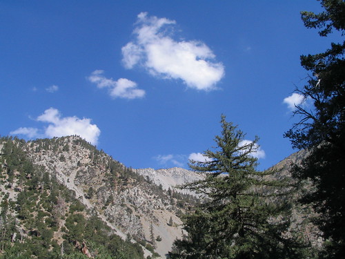
That's it way in the back there. The barren gray peak of Mount San Antonio.
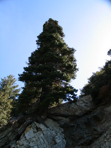
The hike up had a fairly shallow incline, and was kept cool by the mountain's shade. It was a dirt service road up to Baldy Notch, so nothing too terribly interesting on this part of the hike. Except for a few trees desperately clutching the side of the mountain with their roots.
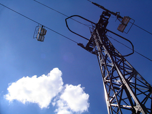
And I got to wind underneath the ski lift, which provided some nice views of the cheaters, as well as the opportunity for some artsy shots of machinery in the mountains.
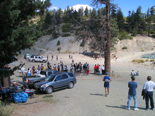
I didn't take any breaks on the way up, planning to stop for a nice rest at the ski lodge atop Baldy Notch. I made good time on the first section, making almost three miles and a 1300 ft. elevation in just over an hour. When I got there, I figured out why there'd been so many cars in the parking lot:
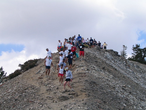
It was the Mount Baldy Run To The Top, a gruelling race that followed the exact trail I was hiking. Although the lodge was crowded, it looked like the race was winding down. Or at least, was in the process of winding down. So I tightened up the backpack, stretched my legs, and fought against the tide of returning runners.
I did my best to ignore the runners, exchanging knowing glances with the few scattered hikers I noticed coming down with them. While they were kicking up a lot of dust on the way down, it was easy to get distracted by the scenery. Early on, I could see into the desert to our east, where thunderclouds were forming on the horizon. They're barely visible here, but the clouds were beautiful to keep checking in on.
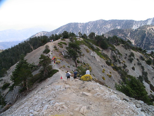
After winding up the side of Mount Hawkins, I'd reached a section of trail known as "The Devil's Backbone." An apt name, as the trail literally straddled the tiny ridge between several mountains, with very steep drops down either side. While I never felt like I was in danger of falling, I could see how, with a strong wind, I'd be a lot more worried about it. Luckily, because of the race, there were rangers stationed fairly regularly along this section of the trail.
While the views were inspiring, the air was refreshing, and the temperature was cool, by this point my legs were letting me know what I was doing to them. And they weren't doing it politely. With my thighs feeling like furnaces and the pangs of pain highlighting joints I never knew I had, I sat down on a boulder for my Clif Bar and apple lunch. Just in time to see about 200 stragglers from the race slowly making their way down the mountain in an achey, limping pack. A mountain lion's dream.
Watching those runners come down, my own pains seemed pretty insignificant. Those guys had all just done what I was doing, and they were running. No CamelBak, no Clif Bars, no sturdy hiking boots. I stretched and took off again, stopping once more to look back at the Backbone Trail.
Right along the ridge!
After rounding a few more bends, and occasionally hanging onto the side of the mountain for dear life, I had made it to the final stretch. So close!
But one of the nastiest things about this trail, other than the punishing and relentless ascent from Baldy Notch, is that the final stretch is one of the steepest parts of the entire trail. From the bottom, it looked like a giant stairless staircase. Everyone's brain at this point was an equal mix of "Sweet Jesus, that is too steep. Make it stop!" and "You're almost there! Go! Go!"
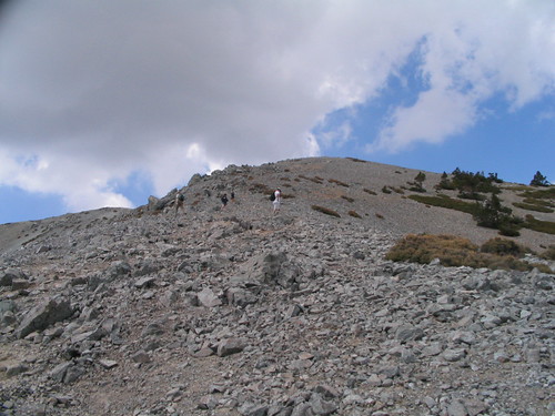
The unwritten Hikers' Creed states that descending hikers must encourage their fellow hikers who are still on their way up, especially if they look like they're in pain. And let me tell you, it helps. Hearing you're almost there - even when you're not quite almost there - can be the last spark you need to make your legs keep moving for that final stretch. It's also nice to be on the way down and tell a sweating, limping, creaking hiker that it's all going to be worth it when he gets to the top, breathes in deep, and collapses on the summit marker.
Which is pretty much exactly what I did.
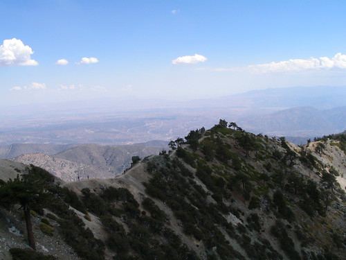
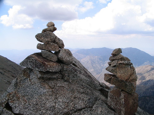
I found a perfectly recliner-shaped rock, took off my backpack, settled in, and literally took a nap. A very short nap, but I did nod off for a minute or two, taking in the cool breeze and relative isolating silence (thankfully, only a few other hikers were still hanging around the peak). After waking up, I sat on an exposed boulder, looking out into the vast distance and admiring both the natural peaks and those of the cairns past hikers had left behind them.
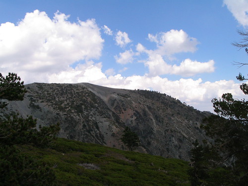
After spending a good half hour drinking in the vistas, I decided to head back down via the Baldy Bowl Trail, instead of back to the ski lodge and lift (still cheating!). The descent was more pronounced on this trip, and the terrain much more rugged. Although shorter, distance-wise, than the Backbone route, I could neither imagine nor recommend trying to come up this way if you have any intention of walking for the rest of the week. The trail down, however, did provide several scale-setting views of the trail I came in on.
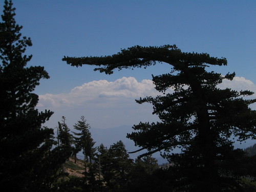
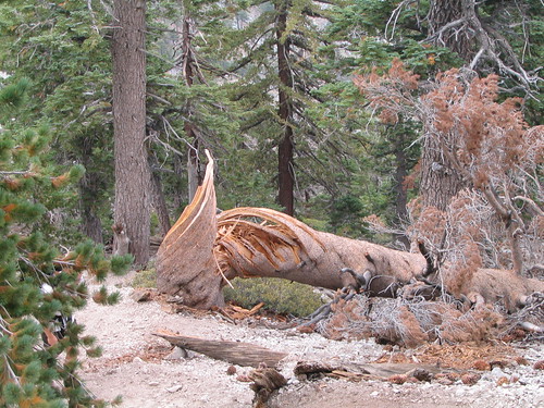
... as well as an amazing tree, bent into a 90-degree angle by some past avalanche or landslide.
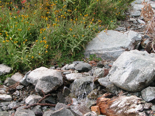
In the Baldy Bowl, the temperature grew warmer and plants stretched in every direction, fed by the tiny stream that eventually became San Antonio Falls back at the trailhead. A fragrant, peaceful way to continue the trail back to the car...
... Where I promptly let out one of nature's most exhausted sighs.
A fantastic hike, by all accounts. And my first 10,000!
And now, statistics! 'Cause I'm keeping track of them now.
Start Time: 9:19AM
Time at Summit: 12:58PM
Finish Time: 3:42PM
Round trip mileage: 11.56 miles. apx.
Footsteps: 22,947
Elevation Gain: 3800'
And, as always more pictures up on Flickr.
Unfortunately, it was still closed. Fire damage. For some reason that day - maybe due to an extra influx of vacationing tourists on their day off - the rangers were uncharacteristically unhelpful. I was far east in the forest, surrounded by short trails. I didn't drive all the way out there to do something easy. What was left? Mount Baldy?
The tallest mountain in Los Angeles County, 'Old Baldy' - or more accurately Mount San Antonio - is clearly visible from the city of Los Angeles. You know, when there's no smog around. It's also the birthplace of Southern California's ski resort industry. Oh, and it's over 10,000 feet high.
I wasn't planning on doing Mt. Baldy yet, but hell - my CamelBak was full, and I wasn't about to drive back home to do laundry. So off to Mount Baldy I went.
After driving through the picturesque Alpine ski village, the Accord and I climbed the narrow switchbacks to the border of the National Forest. Manker Flats campground was full, and the place was crawling with families and cars. I drove up to the Mount Baldy Ski Lifts to check 'em out. Parking lot full again.
I could take the ski lift up to Baldy Notch. It'd cut about two miles off the hike, and a hell of a lot of elevation gain. But would climbing L.A. County's highest mountain with the aid of a lift cheapen the accomplishment?
Hell yeah it would. 'Fuck the lifts,' I thought. 'I'm hiking.'
And with that, I hit the trail.
Under a perfectly blue California Sky, I wound through some fragrant cedars in the cool mountain air. The quiet roar of San Antonio Falls provided some nice white noise as I rounded a bend and saw just how far this hike was going to take me.
That's it way in the back there. The barren gray peak of Mount San Antonio.
The hike up had a fairly shallow incline, and was kept cool by the mountain's shade. It was a dirt service road up to Baldy Notch, so nothing too terribly interesting on this part of the hike. Except for a few trees desperately clutching the side of the mountain with their roots.
And I got to wind underneath the ski lift, which provided some nice views of the cheaters, as well as the opportunity for some artsy shots of machinery in the mountains.
I didn't take any breaks on the way up, planning to stop for a nice rest at the ski lodge atop Baldy Notch. I made good time on the first section, making almost three miles and a 1300 ft. elevation in just over an hour. When I got there, I figured out why there'd been so many cars in the parking lot:
It was the Mount Baldy Run To The Top, a gruelling race that followed the exact trail I was hiking. Although the lodge was crowded, it looked like the race was winding down. Or at least, was in the process of winding down. So I tightened up the backpack, stretched my legs, and fought against the tide of returning runners.
I did my best to ignore the runners, exchanging knowing glances with the few scattered hikers I noticed coming down with them. While they were kicking up a lot of dust on the way down, it was easy to get distracted by the scenery. Early on, I could see into the desert to our east, where thunderclouds were forming on the horizon. They're barely visible here, but the clouds were beautiful to keep checking in on.
After winding up the side of Mount Hawkins, I'd reached a section of trail known as "The Devil's Backbone." An apt name, as the trail literally straddled the tiny ridge between several mountains, with very steep drops down either side. While I never felt like I was in danger of falling, I could see how, with a strong wind, I'd be a lot more worried about it. Luckily, because of the race, there were rangers stationed fairly regularly along this section of the trail.
While the views were inspiring, the air was refreshing, and the temperature was cool, by this point my legs were letting me know what I was doing to them. And they weren't doing it politely. With my thighs feeling like furnaces and the pangs of pain highlighting joints I never knew I had, I sat down on a boulder for my Clif Bar and apple lunch. Just in time to see about 200 stragglers from the race slowly making their way down the mountain in an achey, limping pack. A mountain lion's dream.
Watching those runners come down, my own pains seemed pretty insignificant. Those guys had all just done what I was doing, and they were running. No CamelBak, no Clif Bars, no sturdy hiking boots. I stretched and took off again, stopping once more to look back at the Backbone Trail.
Right along the ridge!
After rounding a few more bends, and occasionally hanging onto the side of the mountain for dear life, I had made it to the final stretch. So close!
But one of the nastiest things about this trail, other than the punishing and relentless ascent from Baldy Notch, is that the final stretch is one of the steepest parts of the entire trail. From the bottom, it looked like a giant stairless staircase. Everyone's brain at this point was an equal mix of "Sweet Jesus, that is too steep. Make it stop!" and "You're almost there! Go! Go!"
The unwritten Hikers' Creed states that descending hikers must encourage their fellow hikers who are still on their way up, especially if they look like they're in pain. And let me tell you, it helps. Hearing you're almost there - even when you're not quite almost there - can be the last spark you need to make your legs keep moving for that final stretch. It's also nice to be on the way down and tell a sweating, limping, creaking hiker that it's all going to be worth it when he gets to the top, breathes in deep, and collapses on the summit marker.
Which is pretty much exactly what I did.
I found a perfectly recliner-shaped rock, took off my backpack, settled in, and literally took a nap. A very short nap, but I did nod off for a minute or two, taking in the cool breeze and relative isolating silence (thankfully, only a few other hikers were still hanging around the peak). After waking up, I sat on an exposed boulder, looking out into the vast distance and admiring both the natural peaks and those of the cairns past hikers had left behind them.
After spending a good half hour drinking in the vistas, I decided to head back down via the Baldy Bowl Trail, instead of back to the ski lodge and lift (still cheating!). The descent was more pronounced on this trip, and the terrain much more rugged. Although shorter, distance-wise, than the Backbone route, I could neither imagine nor recommend trying to come up this way if you have any intention of walking for the rest of the week. The trail down, however, did provide several scale-setting views of the trail I came in on.
... as well as an amazing tree, bent into a 90-degree angle by some past avalanche or landslide.
In the Baldy Bowl, the temperature grew warmer and plants stretched in every direction, fed by the tiny stream that eventually became San Antonio Falls back at the trailhead. A fragrant, peaceful way to continue the trail back to the car...
... Where I promptly let out one of nature's most exhausted sighs.
A fantastic hike, by all accounts. And my first 10,000!
And now, statistics! 'Cause I'm keeping track of them now.
Start Time: 9:19AM
Time at Summit: 12:58PM
Finish Time: 3:42PM
Round trip mileage: 11.56 miles. apx.
Footsteps: 22,947
Elevation Gain: 3800'
And, as always more pictures up on Flickr.
Labels: hiking
that one guy you know, 9:43 PM
 |
|  |
|  |
|  |
|  |
|  |
|  |
|  |
|  |
|
| | | | | | | | |
1 Comments:
Congrats on the hike! I'm envious--we have two crappy mountains here in Atlanta, and one is carved to look like some random confederate generals. Neither is a great option for hiking, even if the weather wasn't 4 million degrees with 120% humidity.


