The Obligatory
"Play safe. Ski only in clockwise direction. Let's all have fun together."
Sunday, October 08, 2006
Hiking Catch-up: Devil's Punchbowl and Strawberry Peak
... and yes, I have taken to only hiking the most whimsically named features of the Angeles National Forest.
Last week, before I got swamped with Tokyo updates and crazy scriptwriting at work, Will, Dingo, and I drove up to the north side of the San Gabriels to check out something called the Devil's Punchbowl - an area near the San Andreas and Punchbowl faults where - basically - a large area of sedimentary sandstone is getting pulled apart by plate tectonics.
Geology, ho!
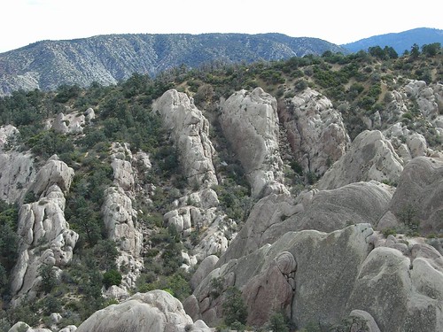
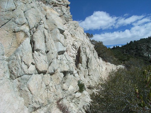
In some places, the rocks just appear to be slanted slightly:
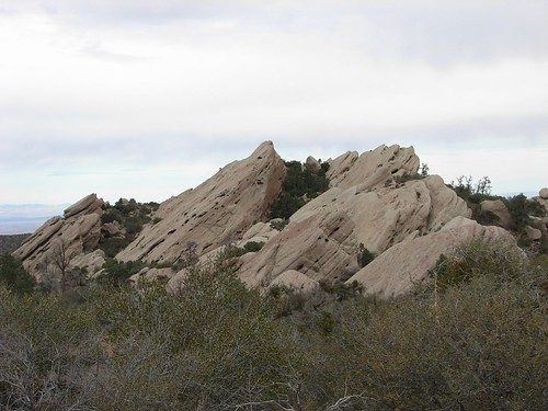
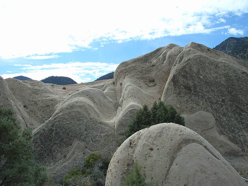
When you get closer to the actual "punchbowl" area, though, you see giant slabs of rock - which started horizontally - tilted almost vertically.
After being exposed like that for so long, the slabs get warped even further by wind and water, which makes them look even more bizarre than they already do. If I were a geology teacher, which I am woefully unqualified to be, I would take my class here.
It also makes them prime for scramblin', which is exactly what we did. Also, the trail we were going to do was closed due to fire danger, and we sure as hell didn't drive all the way out to Pearblossom to do a one mile loop trail. No sir.
We squeezed through some water-sliced boulders and wedged our ways up to the top of one of the large formations in the center of the punchbowl. This includes Dingo, of course. The Amazing Vertically-walking Dog. It's really amazing just to watch her as she scrambles through the trails with us.
Man, I want a dog.
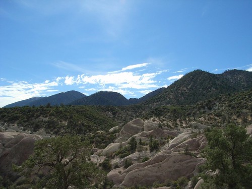
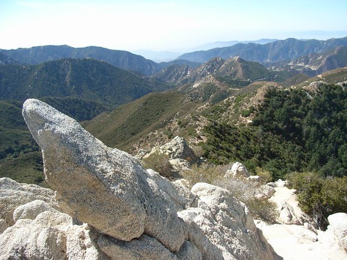
As we reached the top of the second rock structure we climbed, the clouds broke and revealed one of those classic California Blue Skies. We walked to our personal sandstone horizon, and got our - or at least my - first view of the northern San Gabriels.
More pics from the Punchbowl are up on Flickr. And on these, I had about 80% figured out how to use the billions of photo options on my new camera.
Today, we had another meeting scheduled with the East Fork trail and Bridge to Nowhere, but due to an alarm clock malfunction, I ended up heading back to the San Gabriels on my own.
I was going to do a hike up to Josephine Peak, which didn't look too difficult or exciting, but I wanted to cross another peak off my Hundred Peaks List, and Josephine was on it. I altered the recommended (and really boring) fire road route by starting the hike at Colby Canyon trailhead. Fortunately for me, a rather colorful older gentleman hiker was also gearing up there with his daughter. When I said hello, as all good hikers do, we chatted for a little bit.
"Where ya headed?" He asked.
I explained, briefly, my situation.
"Well, ya know, Strawberry's a better climb."
I asked him about the rock-climbing to get to the top. He laughed, but not dismissively. More in a sort of "crazy old guy at the bottom of a trail out the middle of nowhere" way.
"Nah, you forget about that. Just do Strawberry. You'll like it."
I thanked him and adjusted my sights on Strawberry Peak, the rounded summit visible from the trailhead.

As I walked onto the trail, I could still hear him telling his daughter about the different types of clouds in the sky. "It's gon' be a windy one today!"
I love hikers.
The lower parts of the canyon were densely wooded with sycamore and poison oak. Since it's getting late in the season, all plants of the itch-producing varieties had already turned or started to turn bright red. This is good, as there was a lot of it lining the trail, and I probably would have missed a few patches if it wasn't already the Color of Danger.
The hike up through Colby Canyon was easy enough, and had some pleasant, shaded areas to cool off in before trudging through the much longer sunshine-exposed sections. Underneath a particularly nice group of large manzanitas, I met an older couple who were hiking to Josephine Peak. One of them gave me some helpful tips on finding the "Mountaineer's Route" up to the top of Strawberry - an unofficial yet still marked and maintained trail that offered some nice climbing and a shorter distance to the top than its more official brother. I thanked them and continued up the trail.
Right before the turn off to Strawberry Peak, there was a large concrete water tank with a pretty terrible poem scrawled on it in black marker. I wish I could remember it, but I obviously didn't think enough of it to take a picture. I'm pretty sure the line "might makes right" was in there. All of my critiques, however, pale to the one that was written next to it, also in black sharpie:
I wish more literary criticism was so succinct.
A few meters away from Josephine Saddle, I found the well-worn side path up to the Mountaineer's Route. Following the purple arrows that had been spraypainted on the rocks, it soon became quite apparent why they called this the Mountaineer's Route. It's 'cause you're gonna be climbing up a mountain. Emphasis on the word "climbing." A few hundred feet up the Route, this is the first obstacle you see:
And no, you don't go around it. You go up it.
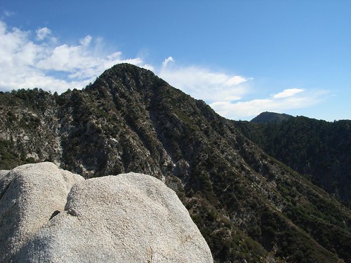
So after a few moments of tentative hesitation (I wouldn't be myself if I wasn't hesitating, really), I started holding onto sandstone and hoisting myself up. And after a few minutes - a large portion of which was spent thinking about what would happen if I fell, and how long it would take for anyone to even start to look for me - I made it to the top. My reward, a view of the valleys and peaks surrounding me, unfolding in an unobstructed view.
And to my left, the target peak, still a healthy hike and climb away from me.
Continuing on the trail, it also became clear that this was a highly unofficial and slightly unmaintained trail. While the path was marked at regular intervals with those spraypainted arrows, large sections of the trail were nearly covered with plants -- most of which was thorny and/or spiky. On this particular section, I actually had to walk through bent over, all of my exposed skin vulnerable to the prickly bushes surrounding me.
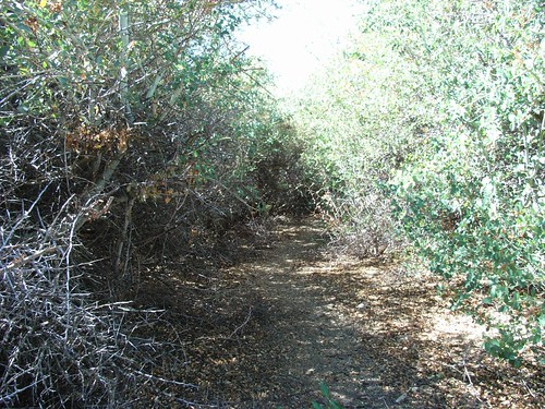
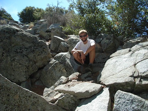
This part of the hike went much, much slower than it should have, mostly due to my extremely careful navigation of Thorn Tunnels like that one and tight passageways filled with extra-painful Spanish bayonets. Eventually, I got to a large pile of broken boulders near the peak, and after climbing down (and up again), I stopped to pose for a pic with my fancy new GorillaPod, which I hope will allow me to get a bit more perspective on the rises on some of these solo hikes. Everything just looks so much less impressive when there's nothing to give you that human scale.
Right after this, I reached the sheer, granite face of Strawberry Peak itself. From here, it was a healthy distance of nearly-vertical climbing, with pretty steep cliffs on all sides of me. The climbing was slow (due mostly to paranoia on my part), but not too difficult, thanks to those helpful spraypainted arrows. I always knew where my hands and feet had to go ... it was just a matter of getting them there.
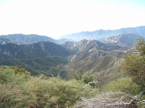
Eventually, I did make it to the top, and was rewarded not only with a great sense of accomplishment (never in any of my 25 years would I ever have told you I would be climbing class 3-4 boulders by myself at some point in the future) and beautiful views of Colby Canyon. Right in the center of this picture is the trailhead I started at. Which is pretty amazing, if you ask me.
After stopping to eat a quick lunch and sign the peak register, I made my way back down via the Red Box Trail, as I wasn't too keen to climb down that sheer rock face I'd just climbed up. In retrospect, this was a bad decision, as it added about 6 additional miles to my hiking trip when I was already looking forward to a nice shower, but hey - lesson learned.
I can't wait to get back there. And find more places to climb.
More pics of this one are up on Flickr, too, if you're interested.
Last week, before I got swamped with Tokyo updates and crazy scriptwriting at work, Will, Dingo, and I drove up to the north side of the San Gabriels to check out something called the Devil's Punchbowl - an area near the San Andreas and Punchbowl faults where - basically - a large area of sedimentary sandstone is getting pulled apart by plate tectonics.
Geology, ho!
In some places, the rocks just appear to be slanted slightly:
When you get closer to the actual "punchbowl" area, though, you see giant slabs of rock - which started horizontally - tilted almost vertically.
After being exposed like that for so long, the slabs get warped even further by wind and water, which makes them look even more bizarre than they already do. If I were a geology teacher, which I am woefully unqualified to be, I would take my class here.
It also makes them prime for scramblin', which is exactly what we did. Also, the trail we were going to do was closed due to fire danger, and we sure as hell didn't drive all the way out to Pearblossom to do a one mile loop trail. No sir.
We squeezed through some water-sliced boulders and wedged our ways up to the top of one of the large formations in the center of the punchbowl. This includes Dingo, of course. The Amazing Vertically-walking Dog. It's really amazing just to watch her as she scrambles through the trails with us.
Man, I want a dog.
As we reached the top of the second rock structure we climbed, the clouds broke and revealed one of those classic California Blue Skies. We walked to our personal sandstone horizon, and got our - or at least my - first view of the northern San Gabriels.
More pics from the Punchbowl are up on Flickr. And on these, I had about 80% figured out how to use the billions of photo options on my new camera.
Today, we had another meeting scheduled with the East Fork trail and Bridge to Nowhere, but due to an alarm clock malfunction, I ended up heading back to the San Gabriels on my own.
I was going to do a hike up to Josephine Peak, which didn't look too difficult or exciting, but I wanted to cross another peak off my Hundred Peaks List, and Josephine was on it. I altered the recommended (and really boring) fire road route by starting the hike at Colby Canyon trailhead. Fortunately for me, a rather colorful older gentleman hiker was also gearing up there with his daughter. When I said hello, as all good hikers do, we chatted for a little bit.
"Where ya headed?" He asked.
I explained, briefly, my situation.
"Well, ya know, Strawberry's a better climb."
I asked him about the rock-climbing to get to the top. He laughed, but not dismissively. More in a sort of "crazy old guy at the bottom of a trail out the middle of nowhere" way.
"Nah, you forget about that. Just do Strawberry. You'll like it."
I thanked him and adjusted my sights on Strawberry Peak, the rounded summit visible from the trailhead.
As I walked onto the trail, I could still hear him telling his daughter about the different types of clouds in the sky. "It's gon' be a windy one today!"
I love hikers.
The lower parts of the canyon were densely wooded with sycamore and poison oak. Since it's getting late in the season, all plants of the itch-producing varieties had already turned or started to turn bright red. This is good, as there was a lot of it lining the trail, and I probably would have missed a few patches if it wasn't already the Color of Danger.
The hike up through Colby Canyon was easy enough, and had some pleasant, shaded areas to cool off in before trudging through the much longer sunshine-exposed sections. Underneath a particularly nice group of large manzanitas, I met an older couple who were hiking to Josephine Peak. One of them gave me some helpful tips on finding the "Mountaineer's Route" up to the top of Strawberry - an unofficial yet still marked and maintained trail that offered some nice climbing and a shorter distance to the top than its more official brother. I thanked them and continued up the trail.
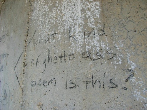
Right before the turn off to Strawberry Peak, there was a large concrete water tank with a pretty terrible poem scrawled on it in black marker. I wish I could remember it, but I obviously didn't think enough of it to take a picture. I'm pretty sure the line "might makes right" was in there. All of my critiques, however, pale to the one that was written next to it, also in black sharpie:
I wish more literary criticism was so succinct.
A few meters away from Josephine Saddle, I found the well-worn side path up to the Mountaineer's Route. Following the purple arrows that had been spraypainted on the rocks, it soon became quite apparent why they called this the Mountaineer's Route. It's 'cause you're gonna be climbing up a mountain. Emphasis on the word "climbing." A few hundred feet up the Route, this is the first obstacle you see:
And no, you don't go around it. You go up it.
So after a few moments of tentative hesitation (I wouldn't be myself if I wasn't hesitating, really), I started holding onto sandstone and hoisting myself up. And after a few minutes - a large portion of which was spent thinking about what would happen if I fell, and how long it would take for anyone to even start to look for me - I made it to the top. My reward, a view of the valleys and peaks surrounding me, unfolding in an unobstructed view.
And to my left, the target peak, still a healthy hike and climb away from me.
Continuing on the trail, it also became clear that this was a highly unofficial and slightly unmaintained trail. While the path was marked at regular intervals with those spraypainted arrows, large sections of the trail were nearly covered with plants -- most of which was thorny and/or spiky. On this particular section, I actually had to walk through bent over, all of my exposed skin vulnerable to the prickly bushes surrounding me.
This part of the hike went much, much slower than it should have, mostly due to my extremely careful navigation of Thorn Tunnels like that one and tight passageways filled with extra-painful Spanish bayonets. Eventually, I got to a large pile of broken boulders near the peak, and after climbing down (and up again), I stopped to pose for a pic with my fancy new GorillaPod, which I hope will allow me to get a bit more perspective on the rises on some of these solo hikes. Everything just looks so much less impressive when there's nothing to give you that human scale.
Right after this, I reached the sheer, granite face of Strawberry Peak itself. From here, it was a healthy distance of nearly-vertical climbing, with pretty steep cliffs on all sides of me. The climbing was slow (due mostly to paranoia on my part), but not too difficult, thanks to those helpful spraypainted arrows. I always knew where my hands and feet had to go ... it was just a matter of getting them there.
Eventually, I did make it to the top, and was rewarded not only with a great sense of accomplishment (never in any of my 25 years would I ever have told you I would be climbing class 3-4 boulders by myself at some point in the future) and beautiful views of Colby Canyon. Right in the center of this picture is the trailhead I started at. Which is pretty amazing, if you ask me.
After stopping to eat a quick lunch and sign the peak register, I made my way back down via the Red Box Trail, as I wasn't too keen to climb down that sheer rock face I'd just climbed up. In retrospect, this was a bad decision, as it added about 6 additional miles to my hiking trip when I was already looking forward to a nice shower, but hey - lesson learned.
I can't wait to get back there. And find more places to climb.
More pics of this one are up on Flickr, too, if you're interested.
Labels: hiking
that one guy you know, 7:45 PM
 |
|  |
|  |
|  |
|  |
|  |
|  |
|  |
|  |
|
| | | | | | | | |
2 Comments:
that "What kind of ghetto ass poem is this?" picture is outstanding.

that "what kind of ghetto poem is this?" picture is outstanding.


